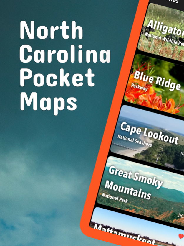
About North Carolina Pocket Maps
Early Spring 2024: Be prepared for your adventure without Wi-Fi or mobile service! Download North Carolina maps for national parks and state parks before you hike. Be prepared! Plan your next trip to one of the great...
Early Spring 2024: Be prepared for your adventure without Wi-Fi or mobile service! Download North Carolina maps for national parks and state parks before you hike.
Be prepared! Plan your next trip to one of the great North Carolina parks. Download maps and guides before you venture into the Wi-Fi free wilderness.
Discover
- 70+ national parks, state parks, monuments, forests
- 50+ neatly folded maps by the National Park Service, Bureau of Land Management, United States Forest Services, and other agencies.
- Motor Vehicle Use Maps (MVUM), Motor Vehicle Travel Maps (MVTM) and visitor maps for California national forests.
- 600+ campgrounds and campsites
- 900+ trails and trailheads
- 61,000+ points of interests
Plan
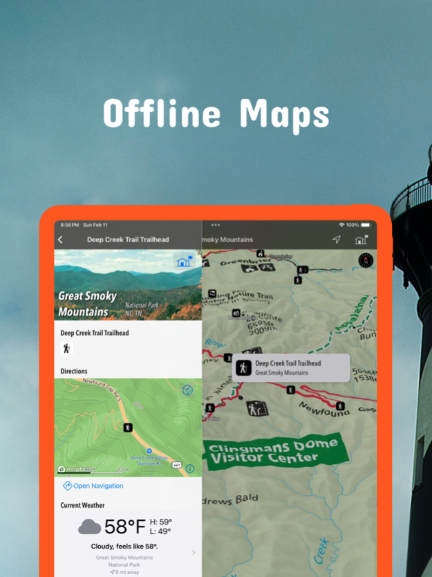
- Download maps, park brochures, and newspapers. These downloads are ready when you are offline and off the grid in the great outdoors.
- Download arbitrary map sections as offline packs.
- Photo galleries, panorama views.
- Share links to parks and maps with friends
Have fun
- GPS and GPX support: record your hikes, import GPX routes, tracks and waypoints for your hiking trails.
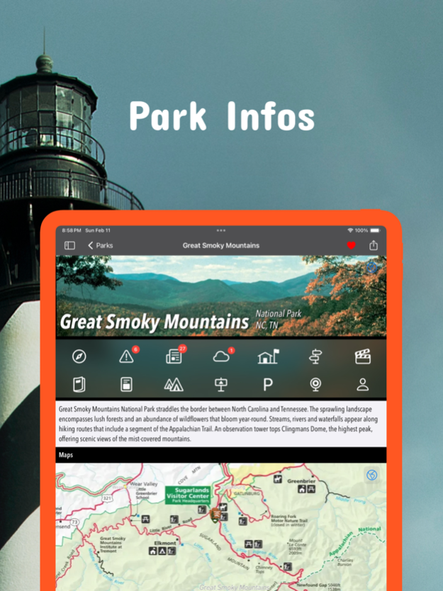
- Detailed national park information: alerts, news, visitor centers, campgrounds, driving directions, weather.
- Open your favorite maps app to get a route to the selected park.
- Current weather conditions, easy access to multi-day forecasts, sunrise and sunset times.
- Push notifications for park alerts, park news, weather warnings
So download maps and guides for:
Blue Ridge
Cape Hatteras
Cape Lookout
Carolina Beach
Chimney Rock
Croatan
Elk Knob
Fort Macon
Fort Raleigh
Gorges
Grandfather Mountain
Great Smoky Mountains
Guilford Courthouse
Hanging Rock
Nantahala
Pisgah
South Mountains
Stone Mountain
Uwharrie
Wright Brothers
There are additional useful information and brochures for:
Appalachian, Carl Sandburg Home, Carvers Creek, Cliffs of the Neuse, Crowders Mountain, Dismal Swamp, Eno River, Falls Lake, Fort Fisher, Goose Creek, Gullah/Geechee, Hammocks Beach, Lumber River, Moores Creek, Overmountain Victory, Pettigrew
- FULL ACCESS is available for a for $3.49/three month (after a free 3-days trial period) or $2.49/two months or $7.49/year. You can subscribe and pay through your iTunes account. The account will be charged for renewal within 24-hours prior to the end of the current period, and identify the cost of the renewal. Your subscription will automatically renew unless canceled at least 24 hours before the end of the current period. Auto-renew can be turned off anytime by going to your Account Settings in iTunes after purchase.
- Continued use of GPS running in the background can dramatically decrease battery life.
LEGAL
Terms of Use: https://www.icoat.de/pocketmaps/terms
Privacy Policy: https://www.icoat.de/pocketmaps/privacy
Mar 25, 2024
Version 6.3
Early Spring 2024
Updates: Great Smoky Mountains
Updates: Contains the latest data by the National Park Service (NPS), Bureau of Land Management (BLM), United States Forest Service (USFS) and recreation.gov.
Previous Versions
Here you can find the changelog of North Carolina Pocket Maps since it was posted on our website on 2021-12-15 20:55:16.
The latest version is 6.3 and it was updated on 2024-04-22 09:19:00. See below the changes in each version.
North Carolina Pocket Maps version 6.3
Updated At: 2024-03-25
Changes: Mar 25, 2024
Version 6.3
Early Spring 2024
Updates: Great Smoky Mountains
Updates: Contains the latest data by the National Park Service (NPS), Bureau of Land Management (BLM), United States Forest Service (USFS) and recreation.gov.
North Carolina Pocket Maps version 6.2
Updated At: 2024-01-31
Changes: Jan 31, 2024
Version 6.2
Winter 2023/2024
Updates: Great Smoky Mountains
Updates: Contains the latest data by the National Park Service (NPS), Bureau of Land Management (BLM), United States Forest Service (USFS) and recreation.gov.
North Carolina Pocket Maps version 6.1
Updated At: 2023-12-24
Changes: Dec 24, 2023
Version 6.1
Early Winter 2023/2024
Updates: Appalachian Trail, Guilford Courthouse, Moores Creek, Smoky Mountains.
Updates: Contains the latest data by the National Park Service (NPS), Bureau of Land Management (BLM), United States Forest Service (USFS) and recreation.gov.
North Carolina Pocket Maps version 6.0
Updated At: 2023-11-09
Changes: Nov 9, 2023
Version 6.0
Fall 2023
Updates: Great Smoky Mountains
Updates: Contains the latest data by the National Park Service (NPS), Bureau of Land Management (BLM), United States Forest Service (USFS) and recreation.gov.
North Carolina Pocket Maps version 5.9
Updated At: 2023-09-01
Changes: Sep 1, 2023
Version 5.9
Summer 2023
New: Watch some interesting videos and audios, produced by the National Park Service.
Updates: Contains the latest data by the National Park Service (NPS), Bureau of Land Management (BLM), United States Forest Service (USFS) and recreation.gov.
North Carolina Pocket Maps version 5.8
Updated At: 2023-07-11
Changes: Jul 11, 2023
Version 5.8
Early Summer 2023
Updates: Contains the latest data by the National Park Service (NPS), Bureau of Land Management (BLM), United States Forest Service (USFS) and recreation.gov.
North Carolina Pocket Maps version 5.7
Updated At: 2023-05-27
Changes: May 27, 2023
Version 5.7
Late Spring 2023
New: We remastered all maps for higher quality and optimized data usage.
Updates: Contains the latest data by the National Park Service (NPS), Bureau of Land Management (BLM), United States Forest Service (USFS) and recreation.gov.
North Carolina Pocket Maps version 5.6
Updated At: 2023-03-31
Changes: Mar 31, 2023
Version 5.6
Spring 2023
Updates: Cape Hatteras, Great Smoky Mountains, Overmountain Victory
Updates: Contains the latest data by the National Park Service (NPS), Bureau of Land Management (BLM), United States Forest Service (USFS) and recreation.gov.
North Carolina Pocket Maps version 5.1
Updated At: 2022-07-31
Changes: Jul 31, 2022 Version 5.1
Summer 2022
New: Redesigned for iPad!
Updates: Carvers Creek, Chimney Rock, Cliffs of the Neuse, Dismal Swamp, Elk Knob
Updates: Contains the latest data by the National Park Service (NPS), Bureau of Land Management (BLM), United States Forest Service (USFS) and recreation.gov.
North Carolina Pocket Maps version 4.8
Updated At: 2022-05-04
Changes: May 4, 2022 Version 4.8
Spring 2022
Updates: With the latest data by NPS, BLM, USFS
Disclaimer
Official App Store Link
We do not host North Carolina Pocket Maps on our servers. We did not scan it for viruses, adware, spyware or other type of malware. This app is hosted by Apple and passed their terms and conditions to be listed there. We recommend caution when installing it.
The App Store link for North Carolina Pocket Maps is provided to you by apps112.com without any warranties, representations or guarantees of any kind, so access it at your own risk.
If you have questions regarding this particular app contact the publisher directly. For questions about the functionalities of apps112.com contact us.